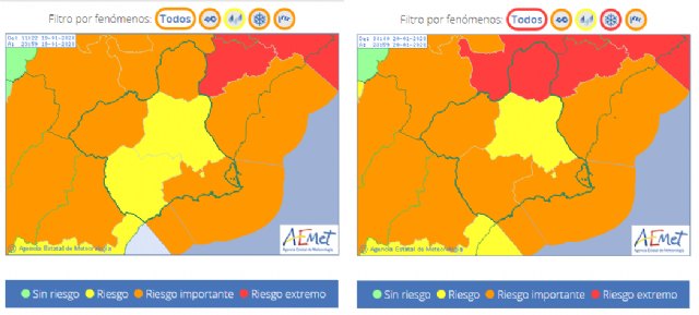
We will try to make a chronology of how this storm is going to develop until Wednesday and detailing the warnings that are activated at this time:
SUNDAY, JANUARY 19
With the advance of the afternoon, time will be complicated.
Rain, snow, wind and cold will be the protagonists, especially in the face of the night.
The snow will end up falling at the end of the day above 700 m altitude.
The wind will be very intense, especially in the coast, Altiplano, Campo de Cartagena and high areas.
NOTICES
ORANGE (SNOW): 10 cm above 700 m in the Altiplano and Northwest
YELLOW (SNOW): 4 cm above 700/800 m in the Guadalent�n Valley, Lorca and Águilas
ORANGE (WIND): gusts of more than 90 km / h in the Altiplano and Campo de Cartagena and Mazarr�n
YELLOW (WIND): gusts of more than 70 km / h in the Guadalent�n Valley, Lorca and Águilas, Noroeste and Vega del Segura
YELLOW (RAIN): 60 mm / 12 h in the Campo de Cartagena and Mazarr�n
ORANGE (WAVE): waves of 3 or 4 m
MONDAY, JANUARY 20
It will be a very unstable day, with abundant and persistent rainfall (with some temporary improvement), locally strong and stormy (especially in the Campo de Cartagena).
They will be of snow above 500 or 600 m, occasionally 400 m in auspicious areas, raising the altitude to 800/1000 m in the afternoon.
The wind will be strong or very strong, especially during the first half of the day.
The maximum temperatures will drop.
NOTICES
RED (SNOW): 20 cm above 500/600 m in the Altiplano (until 12:00 hours)
ORANGE (SNOW): 10 cm above 500/600 m in the Northwest and, after 12:00 hours, in the Altiplano
ORANGE (SNOW): 6 cm above 500/600 m in the Guadalent�n Valley, Lorca and Águilas
ORANGE (WIND): gusts of more than 90 km / h in the Altiplano (until 12:00 hours) and Campo de Cartagena and Mazarr�n (until 10:00 hours)
YELLOW (WIND): gusts of more than 70 km / h in the Guadalent�n Valley, Lorca and Águilas, Noroeste and Vega del Segura (until 10:00 hours) and between 12:00 and 18:00 hours in the Plateau
YELLOW (RAIN): 60 mm / 12 h in the Campo de Cartagena and Mazarr�n
ORANGE (SWELL): waves of 3 or 4 m (until 10:00 hours)
TUESDAY JANUARY 21ST
It will be another unstable day during the first half of the day, with rain that can be abundant at dawn.
In the afternoon they will be weaker and more dispersed.
As temperatures will rise, the snow level will go from 800/1000 m at dawn and first hours to 1400 m in the afternoon.
The wind will be weaker than Monday.
NOTICES
YELLOW (SNOW): 2 cm above 1000 m in the Northwest
WEDNESDAY JANUARY 22
The instability will have moved to the northeast of Spain and in the Region of Murcia only some weak and scattered rain is expected.


